
Ballyhoura Way
- Forestry Tracks
- Tarmac Roads
- Open Moor
- Start at John's Bridge (R576) - Finish at Limerick Junction
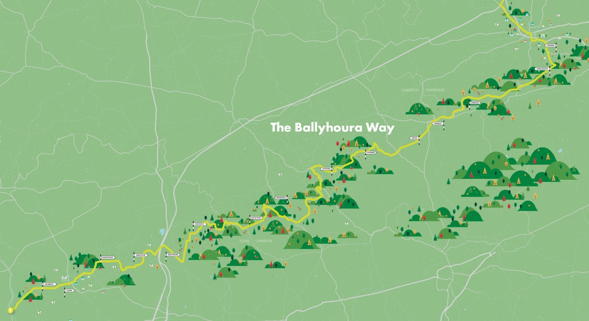
An attractive and varied route through the lush pastureland of the Golden Vale. The Ballyhoura Way is part of the O'Sullivan Beara trail and stretches 90kms from John's Bridge in North Cork to Limerick Junction in Co. Tipperary.
The route crosses four upland stretches, one long one over the Ballyhoura Mountains (highest point Seefin, at 510 metres), two short ones over Benyvoughella Hill and Slievereagh, and then a long traverse on the southern flanks of the Slievenamuck ridge, overlooking the beautiful Glen of Aherlow.
The aggregate ascent over the route is just over 1700m, and apart from a few short steep sections, there are no significant climbs. Along the way, walkers might want to linger at the great Norman castle at Liscarroll, in the pretty villages of Kilfinane, Ballyorgan, Ballylanders and Galbally, or the storied town of Tipperary.
The terrain consists mainly of tarmac roads, forestry tracks, and open moorland and field paths. Some of the road sections are busy and should be used with care: some of the upland sections can be very wet. The Ballyhoura Way is best accessed at one of seven key trailheads, which provide information map boards and car parking.
These are located reasonably close to other services and facilities, such as shops, accommodation, restaurants and public transport. The trailheads are located as follows:
Trailhead 1 – John’s Bridge
John’s Bridge is located on the R576 to Kanturk. A shop and filling station are located at the road junction.
Trailhead 2 – Near Ballyhea
This trailhead is located at Kennedy’s Pub, just off the N20, and is 1km south of Ballyhea.
Trailhead 3 – Green Wood Car Park
Glenosheen is 1km from the junction on R512 to Glenanaar.
Trailhead 4 – Kilfinane
Kilfinane is located on the R517 and is 10km from Kilmallock, 15km from Mitchelstown, and 18km from Tipperary. The trailhead is located at Barrack Street, Kilfinane on the R517.
Trailhead 5 – Ballylanders
Ballylanders is on the R513 and is 10km from Mitchelstown. The trailhead is located at the Commemoration Monument, Main Street, Ballylanders on the R513.
Trailhead 6 – Lisvernane
Lisvernane is located on the R663 and is 10km from Tipperary. The trailhead is located at Christ the King Monument on the R663.
Trailhead 7 – Tipperary Town
Tipperary Town is located on the N24, approximately 40 km from Limerick. The trailhead is located at the Esso Filling Station on the Limerick Road.
PLEASE NOTE that due to farming operations the section between Moor Abbey and Lisvarrinane is temporarily re-routed. From the Moor Abbey side, follow the re-route signs to and through Lisvarrinane village, taking the next minor road on the left. From the Aherlow side, in the woods where the Way originally turned sharp right, follow the re-route signs going straight to shortly join a minor road and continue through Lisvarrinane village, rejoining the original route at Moor Abbey. (January 2022)

Munster Vales wishes to acknowledge funding received under ORIS for development of this campaign.