Rath Beag Loop Walk
- Forestry Roads
- Glenpatrick Woods, Rathgormack
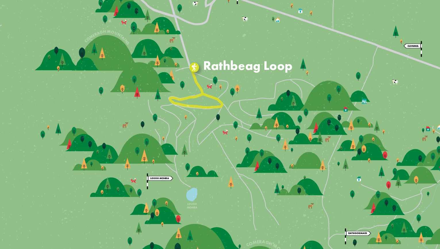
You have a choice of two looped walks through Glenpatrick Wood - a longer one to Lough Mohra, a fine example of a glacial coum, and a shorter one past An Rath Beag, Waterford’s smallest ring fort. The Knockanaffrin Ridge provides a dramatic backdrop throughout.
Directions to Trailhead.
Start: Turn left (south) off the R678 at Glenpatrick Cross about 6 kilometres west of Rathgormack. 700 metres along the forest track you will find room to park at a path junction - S285180.
A-B From the trailhead follow the red (and blue) arrows along the forestry road (blue is for the shorter Rath Beag Loop). Continue for 300m to reach a junction where both loops turn right.
B-C After a short gentle draw, you are rewarded with glorious views of Carrigsheegowna and beyond it, Slievenamon. Soon the path loops back on itself and after a few minutes you reach a four-way junction.
C-D The blue loop (An Rath Beag) goes left here but you are turning right. As you gradually climb, drink in the stark beauty of Knockanaffrin Ridge from Carrigsheegowna on your right to Knocksheegowna on your left. Soon the path loops back on itself again. Off to your left lie the forested plateau of Coolishal and Toor Hill with the Glasha Gorge in between. Continue straight on for the majestic pyramidal peak of Knockanaffrin, the highest point on the ridge at 755 metres. To its left you can make out the “Ass’s Ears” or Crotty’s Rock, and further left, Croughaun Hill. When you reach a 3-way junction where the loop swings left and downhill (D), follow the green arrows straight ahead if you want to view Lough Mohra. When you reach the hairpin bend leave the track and head left for 300 metres across the open mountain until you reach the lake. Called “Loch Mór” in Irish, this lough is anything but big and it is possible to walk around it in ten minutes.
D-E Suitably refreshed, retrace your steps, following the green arrows to the 3-way junction (D). Turn right here and, following the red arrows now, veer left at the next junction. Two minutes later turn right at the four-way junction you met on the way up (C). After a few minutes you will pass An Rath Beag ring fort on the left.
E-A When you reach the T junction, veer left, then left again and less than ten minutes walking west will take you back to the start.
Munster Vales wishes to acknowledge funding received under ORIS for development of this campaign.