Carroll’s Loop
- Woodland Trails
- Forestry Tracks
- Nature Trails
- Lisvarrinane Village, Glen of Aherlow, Co. Tipperary
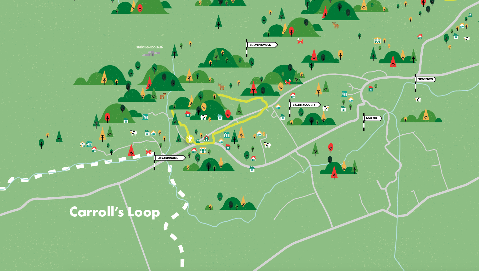
This loop takes you on forest tracks and woodland trails on the slopes of the Hill of Slievenamuck, combining the quietness of secluded boreens with the woodland experience of forest roads and trails.
The name Lisvarrinane comes from the Irish Lios Fearnain, which means the fort of the fairies. The village was developed in the 18th century to service two local landlord families, the Massy’s of Stagdale and the Massy-Dawson’s of Ballinacourty. The church in the village was built in 1889 and is mainly constructed of sandstone with limestone facing. It is popular for weddings of couples not alone from the parish but from all of the neighbouring counties. When William Bulfin, author of Rambles of Eireann, arrived at the top of Slievenamuck and looked down on Lisvarrinane he was completely captivated by what he saw and wrote ‘…the brightness and freshness of its beauty are entrancing… Those green, swelling, smiling fields, that silver stream, the heather clad slopes of the Galtees, and the thick woods along the northern hills are glorious’. This loop is the shortest of three that start and finish at the trailhead in the middle of the village.
A-B. Starting from the village pass the church on your left and turn left onto Carrolls Bohereen from where the loops proper begin. After a short trek along this roadway, you reach a laneway on your right. Turn right here.
B-C. The laneway ascends to reach a forestry track where it joins the long-distance Ballyhoura Way (marked with the standard yellow walking man and arrow). Turn right here – both the blue and red loop turn left.
C-D. Follow the Ballyhoura Way for approximately 1km to reach a 3-way junction. A number of loops merge here (from both the Lisvarrinane and Christ the King trailheads) so be careful to follow the green arrows as your loop turns right continuing to follow the Ballyhoura Way and merging with the blue loop and red loop on the return to the trailhead.
D-E. The forestry road takes you downhill to reach a T-junction of forestry roads where you turn right and shortly afterwards emerge onto a surfaced road. Continue straight here.
E-A. The last section of the loop follows surfaced roadway to emerge at a T-junction at the top of Lisvarrinane village – turn right here and enjoy the 200m back to the trailhead.
Services: Lisvarrinane Village, Co. Tipperary.
Minimum Gear: Trekking shoes, raingear and fluid
Munster Vales wishes to acknowledge funding received under ORIS for development of this campaign.