Padraigh’s Loop
- Woodland Trails
- Forestry Tracks
- Nature Trails
- Lisvarrinane Village, Glen of Aherlow, Co. Tipperary
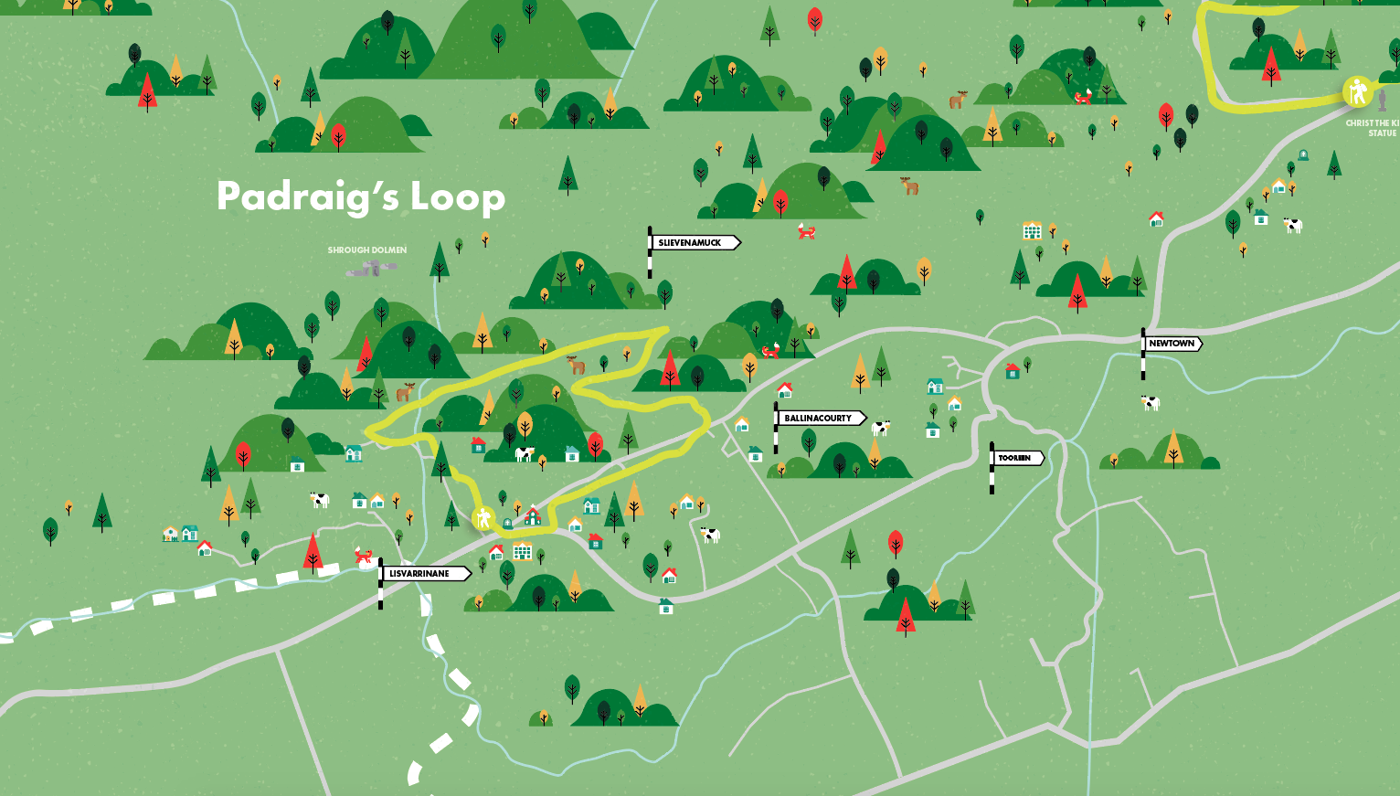
This loop follows forestry tracks and woodland trails as it travels across the shoulder of the Hill of Slievenamuck through Ballinacourty Woods, offering beautiful views towards the village of Galbally, the ruins of Moor Abbey and the beautiful countryside beyond as well as the commanding presence of the Galty Mountains.
This loop is one of three (one shorter, one longer) that start and finish at the trailhead in the middle of the village.
A-B. Starting from Lisvarrinane village pass the church on your left and turn left onto Carrolls Bohereen from where the loops proper begin. After a short trek along this roadway, you reach a laneway on your right. Turn right here.
B-C. The laneway ascends to reach a forestry track where it joins the long-distance Ballyhoura Way (marked with the standard yellow walking man and arrow). The shorter green loop turns right here – you turn left following the blue (and red) arrows. Follow the forestry roadway for another 400m to reach a sharp right bend where the red loop and Ballyhoura Way turn left onto a narrow path. You turn right here - staying on the forestry roadway.
C-D. The loop now travels eastward across the shoulder of Slievenamuck through Ballinacourty Woods. After 2km the loop sweeps right and starts its descent to the trailhead. Shortly afterwards it picks up the red loop from the right and, further downhill at a T-junction it turns right and merges with a purple loop from the Christ the King trailhead, before reaching a 3-way junction.
D-E. A number of loops and the Ballyhoura Way crisscross here so be careful to follow the blue (and green and red) arrows as your loop turns left and follows the Ballyhoura Way and the green loop and red loop. The forestry road takes you downhill to reach a T-junction of forestry roads where you turn right and shortly afterwards emerge onto a surfaced road. Continue straight here.
E-A. The last section of the loop follows surfaced roadway to emerge at a T-junction at the top of Lisvarrinane village – turn right here and enjoy the 200m back to the trailhead.
Services: Lisvarrinane Village, Co. Tipperary.
Minimum Gear: Hiking boots, raingear and fluid

Munster Vales wishes to acknowledge funding received under ORIS for development of this campaign.